


Key Points
- A yellow weather warning has been issued, covering London, much of the South East, and eastern England, starting from 6pm on Sunday until 11am on Monday.
- Visibility during the weather event is forecasted to drop as low as 50 metres, creating difficult and challenging travel conditions across the capital.
- The Met Office has warned that the adverse weather could lead to delays for bus and train services, alongside potential flight delays or cancellations.
- Niamh Murray, Met Office operational meteorologist, explained that long autumn and winter nights, clear skies, and light winds have created the “perfect recipe” for thick fog formation.
- Rural parts of the Midlands, Wales, and East Anglia are expected to face particularly stubborn fog overnight into Monday with temperatures falling close to freezing, bringing the possibility of air frost.
- Milder and wetter weather is anticipated later in the week, with rain forecast from Tuesday to Thursday providing much-needed relief to parts of the South West facing severe drought.
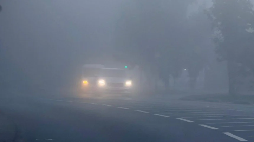
London (West London Times) November 9, 2026 – A severe weather alert has gripped the British capital as thick fog descends on London, causing visibility to plummet to hazardous lows of 50 metres. Transport networks, motorists, and commuters across the region face substantial disruption after official meteorological authorities implemented an urgent yellow weather warning across the capital and surrounding areas.
- Key Points
- What are the details of the yellow weather warning issued for London?
- How is the heavy fog impacting transport and travel conditions?
- What meteorological factors caused this sudden drop in visibility?
- Which other regions across the United Kingdom are affected?
- What changes in weather are expected later in the week?
- Background of the Particular Development
- Prediction on How This Development Can Affect the Particular Audience
What are the details of the yellow weather warning issued for London?
As reported by Ezekiel Bertrand of London Now, a yellow weather warning covering the capital came into force from 6pm on Sunday and is scheduled to remain active until 11am on Monday. The atmospheric phenomenon has created treacherous conditions for drivers and pedestrians alike, with visibility severely restricted across major urban corridors and open roads. The national weather service has highlighted that the densest patches of fog are concentrated directly across the capital, as well as extending heavily into the wider South East and eastern regions of England.
The sudden drop in visibility has placed immediate pressure on transport providers and local infrastructure. According to official advisories, members of the public travelling through the affected regions must prepare for significant commuter disruption.
How is the heavy fog impacting transport and travel conditions?
As detailed by Ezekiel Bertrand of London Now, the Met Office has issued clear warnings that potential delays to both local bus networks and scheduled train services are highly likely while the warning remains active. Furthermore, aviation authorities and passengers have been alerted that regional flights could face unexpected scheduling alterations, including delays or outright cancellations, depending on the severity and persistence of the low-visibility conditions at local airports.
Motorists navigating the capital’s road networks have been urged to exercise extreme caution. With visibility dropping to a stark 50 metres in multiple locations, stopping distances and reaction times are severely compromised, prompting safety campaigns from transport agencies advising drivers to use fog lights and maintain safe distances.
Explore More UK News
Prince Harry Steps Down From Role After 5 Years London 2026
John Healey Delivers First UK Budget Facing Global Economic Storms 2026
What meteorological factors caused this sudden drop in visibility?
Explaining the science behind the weather event, Niamh Murray, Met Office operational meteorologist, stated that current atmospheric conditions have created the “perfect recipe” for thick fog to materialize across the country.
As reported by Ezekiel Bertrand of London Now, Niamh Murray stated that:
“There is still going to be patchy fog elsewhere, just not quite as dense or as impactful. Parts of the West Country could still see fog, Northern Ireland, really anywhere across much of the UK, even into the central belt of Scotland.”
Elaborating on why this specific time of year breeds such intense meteorological events, Niamh Murray stated that:
“With autumn and winter and getting fog during this time of year, we get much longer nights, and that allows temperatures to sort of fall away. We get a longer period of cooling and also the temperatures are much lower, so they’re much closer to the temperature that we need for the air to become saturated and therefore form fog.”
Adding further technical context regarding wind patterns, Niamh Murray stated that:
“Another thing that we need to form fog is quite light winds, not absolutely no winds. We just have the perfect recipe at the moment: light winds, clear skies, long nights, to allow that fog to develop. And particularly if we see the negative numbers, it can quite stubborn to clear the next day.”
Which other regions across the United Kingdom are affected?
While the capital remains a primary focus under the yellow weather warning, the meteorological disruption extends far beyond Greater London. Rural parts of the Midlands, Wales, and East Anglia are experiencing particularly stubborn banks of fog that have lingered overnight into Monday morning.
Temperatures in these outlying and rural sectors are forecasted to plummet close to freezing point. Consequently, meteorological agencies have warned that air frost is entirely possible in localized pockets, adding an extra layer of hazard for early morning commuters and agricultural workers before daytime heating eventually disperses the frost and low-lying moisture.
What changes in weather are expected later in the week?
The persistent fog and chilly conditions are not expected to linger indefinitely, as a shift in the broader jet stream promises a return to active precipitation systems. Forecasters predict that wetter weather patterns will move across the country from Tuesday through Thursday, replacing the stagnant high-pressure setup.
Discussing the upcoming rainfall and its broader environmental benefits, Niamh Murray stated that the incoming precipitation would be “pretty welcome,” noting that most places across the nation are likely to receive consistent accumulations measuring between 10mm and 20mm, with some select locations potentially recording around 30mm.
Crucially, parts of the South West of England—where severe drought conditions have previously been officially declared—are anticipated to receive significantly heavier downpours. Niamh Murray stated that slow-moving rain systems in those drought-hit sectors could produce total accumulations ranging between 50mm and 70mm, offering substantial relief to depleted local reservoirs and parched agricultural land.
Background of the Particular Development
The issuance of this latest yellow weather warning reflects the classic meteorological transition typical of late autumn and early winter in the United Kingdom. High-pressure systems frequently anchor over the British Isles during these months, bringing clear skies and slack pressure gradients. Combined with rapidly cooling ground temperatures and lengthening nights, these atmospheric ingredients routinely trap moisture in the lowest layer of the troposphere, forming radiation fog. Historically, London’s dense urban environment and river valleys have made it uniquely susceptible to thick fog events—famously known in past centuries as “pea-soupers.” While modern forecasting allows for early yellow warnings to mitigate large-scale disasters, recurring weather alerts highlight the persistent vulnerability of modern transport and infrastructure to ancient meteorological cycles.
Prediction on How This Development Can Affect the Particular Audience
For the local London audience, daily commuters, and regional transport operators, this weather development serves as a sharp reminder of seasonal transport fragility. The immediate impact centers on severe morning delays, disrupted work schedules, and logistical bottlenecks across train lines, bus corridors, and flight paths. Over the subsequent 24 to 48 hours, local residents must factor in extended journey times and potential safety hazards on the roads. However, the broader meteorological shift toward widespread rainfall later in the week offers a positive outlook for regional water security, aiding drought-stricken areas in the South West and replenishing natural water tables following months of dry conditions.