

Canal bridges in West London form an important part of the area’s industrial heritage, transport infrastructure and urban landscape. These structures cross the Grand Union Canal, the Paddington Arm and connected waterways, linking neighbourhoods such as uk/local/hounslow/brentford/">Brentford, ealing/hanwell/">Hanwell, Southall, Hayes, Uxbridge and Paddington.
- What are canal bridges in West London?
- When were West London’s canal bridges built?
- How did industrial expansion influence bridge construction?
- Why do some bridges look older than others?
- Which historic canal bridges should visitors look for in West London?
- How does the Three Bridges structure work?
- What architectural features distinguish West London’s canal bridges?
- Why are brick arch bridges common?
- What makes iron bridges historically important?
- How do modern bridges differ from historic crossings?
- Where can residents walk to see canal bridges in West London?
- What can visitors see around Brentford?
- What can visitors see around Hanwell?
- What can visitors see along the Paddington Arm?
- How do canal bridges support West London’s transport network today?
- How should visitors plan a canal bridge walk in West London?
- What should visitors check before setting out?
- How can visitors observe bridges safely?
- What should photographers look for?
- How do West London’s canal bridges contribute to heritage and the environment?
- How do canal bridges contribute to local heritage?
- How do canal corridors support wildlife?
- Why does bridge conservation matter?
- What is the future of canal bridges in West London?
West London’s canal bridges include historic brick arches, iron structures, modern road crossings, railway bridges and unusual engineering works. Some date from the canal-building period of the late eighteenth and nineteenth centuries. Others reflect later industrial expansion, railway construction and urban redevelopment.
The Grand Union Canal connects the River Thames at Brentford with the wider inland waterway network leading towards Birmingham. The Paddington Arm branches towards Paddington Basin, passing through several residential and commercial districts. Both waterways contain bridges that reveal how engineers adapted roads, railways and footpaths to the requirements of canal navigation.
The bridges also support modern walking, cycling, boating and wildlife observation. They provide access between residential streets, industrial estates, parks and waterside paths. Understanding their history helps residents and visitors appreciate the relationship between West London’s waterways and the development of the surrounding communities.
What are canal bridges in West London?
Canal bridges in West London are structures that carry roads, railways, footpaths or other transport routes across navigable waterways. They include historic masonry arches, iron bridges, railway crossings and modern road structures along the Grand Union Canal and Paddington Arm.
A canal bridge solves a practical engineering problem. When a canal cuts across an existing road, railway or pedestrian route, the crossing must preserve access while allowing boats to travel along the waterway.
Some bridges carry roads above the canal. Others carry the canal over a railway or road using an aqueduct, which is a structure designed to transport water across an obstacle. West London contains examples of both arrangements, including unusual structures where several transport routes intersect.
The main waterways associated with West London’s canal bridges are the Grand Union Canal and its Paddington Arm. The main canal reaches the River Thames at Brentford, while the Paddington Arm connects the main waterway near Hayes with Paddington.
According to the Canal & River Trust, the Grand Union Canal extends approximately 137 miles between London and Birmingham. Its route passes through urban districts, industrial areas and countryside. Its western London section combines historic infrastructure with modern housing, commercial developments and recreational routes.
Canal bridges therefore serve several functions. They maintain road and pedestrian connections, preserve navigable waterways and contribute to the area’s historic character. Their construction materials and designs also provide evidence of changing engineering methods.
When were West London’s canal bridges built?
Most historic canal bridges in West London originated during the late eighteenth and nineteenth centuries, when canal construction expanded Britain’s inland transport network. Later railway development, road improvements and twentieth-century redevelopment introduced additional bridges and altered older crossings.
The development of West London’s canal bridges followed the expansion of the Grand Junction Canal, the original name of the principal waterway now forming part of the Grand Union Canal.
Parliament authorised the Grand Junction Canal in 1793. Construction began that year under the direction of engineer William Jessop, with James Barnes responsible for much of the construction work. The section between Brentford and Uxbridge opened in November 1794, and the canal was completed through to Braunston in 1805.
The new waterway connected the River Thames with important inland manufacturing and commercial centres. It reduced reliance on longer transport routes and supported the movement of coal, grain, timber, building materials and other goods.
Building the canal required engineers to cross existing roads and footpaths without interrupting local movement. Bridge construction became an essential part of the project. Brick and stone arches were common because they provided durable structures capable of carrying the traffic of the period.
How did industrial expansion influence bridge construction?
During the nineteenth century, railways created new engineering challenges along the canal corridor. Railway companies needed routes across established waterways, industrial sites and roads.
Brentford, Southall and Hanwell experienced changes associated with industrial and transport development. Warehouses, factories, docks and railway connections increased the importance of the canal network.
The development of Brentford Dock provides a notable example. Engineer Isambard Kingdom Brunel designed the dock for the Great Western Railway, and it was completed shortly after his death in 1859. Its railway connection required infrastructure that accommodated both the canal and existing road routes.
The resulting bridges and crossings illustrate how canal infrastructure adapted to competing transport systems. Their history reflects the transition from horse-drawn canal traffic to steam railways, motor vehicles and modern urban transport.
Why do some bridges look older than others?
The age and appearance of a bridge depend on its original purpose, construction material, maintenance history and subsequent alterations.
A brick arch retains a traditional appearance because its basic structural form often survives even when nearby roads have changed. A railway bridge displays different features because it must support heavier concentrated loads and accommodate railway clearance requirements.
Some historic bridges have been widened, strengthened or partly reconstructed. Others remain recognisable examples of nineteenth-century engineering. A bridge’s present appearance does not always indicate the age of every part of its structure.
Which historic canal bridges should visitors look for in West London?
West London contains notable historic canal crossings, including Gallows Bridge in Brentford and the unusual Three Bridges structure at Hanwell. These locations illustrate the area’s industrial development, historic road connections and the engineering challenges created by intersecting transport routes.
Visitors interested in canal architecture should explore the Grand Union Canal corridor between Brentford, Hanwell, Southall and Hayes. These neighbourhoods contain a mixture of historic crossings, railway structures and modern bridges.
The most rewarding locations combine visible engineering features with accessible towpaths and nearby historic landmarks.
Gallows Bridge, Brentford
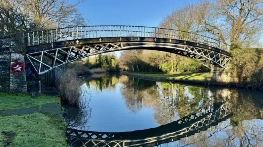
Gallows Bridge is a historic iron bridge associated with the Grand Union Canal and Boston Manor conservation area in Brentford. Hounslow Council’s conservation appraisal identifies the structure as Grade II listed and dates it to 1820. It was manufactured at Horseley Ironworks near Tipton in Staffordshire.
The bridge carries the canal towpath from one side of the waterway to the other. Its location reflects the practical need to maintain pedestrian access while accommodating canal-side industrial premises and warehouses.
The use of iron is particularly significant. During the Industrial Revolution, improved ironworking made it possible to manufacture structural components away from the final construction site. These components could then be transported and assembled where required.
Gallows Bridge provides a useful example of the relationship between industrial manufacturing and canal engineering. Its listed status also identifies it as a structure of recognised architectural or historic interest.
Visitors should observe the bridge from publicly accessible towpath areas and avoid climbing onto its structure or entering restricted industrial premises.
Three Bridges, Hanwell
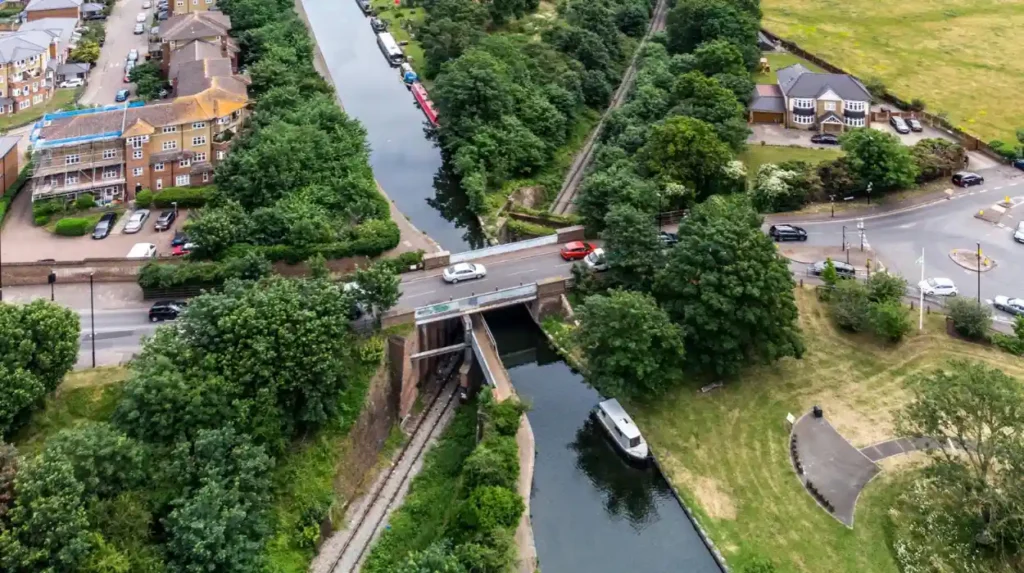
Three Bridges, also known locally as Windmill Bridge, is one of West London’s most distinctive transport-engineering structures. It brings together three routes: Windmill Lane, the Grand Union Canal and a railway line.
The unusual arrangement developed during the nineteenth century, when a railway connection to Brentford Dock had to cross the canal near an existing road crossing.
Rather than constructing a completely separate arrangement for every route, engineers integrated the infrastructure. The railway passes beneath the canal, which is carried in an iron trough aqueduct, while the road crosses above the combined arrangement.
The structure demonstrates how engineers accommodated different transport systems within a restricted urban space. The canal continues through its water-filled trough, the railway passes below, and road traffic travels above.
The aqueduct is particularly important because it carries the canal water itself rather than simply providing a bridge over the waterway. Its design illustrates the distinction between a conventional canal bridge and a canal-carrying aqueduct.
Three Bridges is a valuable destination for people interested in civil engineering, railway history and industrial archaeology. Visitors should use designated public access routes and respect railway safety restrictions.
Brentford Bridge and the historic canal junction
Brentford contains historic crossings associated with both the River Brent and the Grand Union Canal. The development of the canal changed the local waterway landscape by creating a more direct navigable route between the Thames and inland destinations.
The historical record describes an earlier three-arched brick bridge that created difficulties for boats navigating the waterway. A later single-arch granite bridge was built in 1824 as part of improvements associated with Thames Lock, followed by further alterations to accommodate changing transport requirements.
Brentford is also the location of the final lock connecting the Grand Union Canal with the tidal River Thames. The Canal & River Trust identifies Brentford as an important place for understanding the relationship between canal navigation and river transport.
The area is suitable for a walk combining bridge architecture, canal history and waterside views. Visitors can also explore the surrounding town centre and historic transport landscape.
How does the Three Bridges structure work?
Three Bridges at Hanwell combines a road crossing, a canal aqueduct and a railway underpass in one integrated engineering arrangement. Each component supports a different transport function while maintaining the continuity of the road, railway and navigable waterway.
Three Bridges demonstrates the engineering principle of separating intersecting transport routes vertically. Instead of requiring each route to cross the others at ground level, the structure places them at different heights.
The road crossing allows vehicles and pedestrians to travel across the canal corridor. The railway passes beneath the canal, and the canal remains elevated within its supporting aqueduct.
This arrangement reduces the need for moving bridges or repeated interruptions to canal navigation. It also allows the railway and road to operate without requiring boats to stop whenever a train or vehicle passes.
What is a canal aqueduct?
A canal aqueduct is a structure that carries water across an obstacle, such as a road, railway, valley or smaller watercourse.
Unlike a conventional bridge that carries traffic over a canal, an aqueduct supports the canal itself. Its structure must retain water and resist the weight of the water, supporting materials and any additional loads imposed by the design.
At Three Bridges, the canal is carried through an iron trough above the railway. This solution allowed engineers to preserve the waterway while constructing a railway connection beneath it.
Aqueducts require careful engineering because they combine the structural demands of a bridge with the need to maintain a watertight channel.
Why was this arrangement necessary?
The railway connection to Brentford Dock had to pass through an established transport corridor. The canal and Windmill Lane already occupied important crossing positions.
Constructing a railway at a different level allowed the new line to connect with the dock without permanently severing the road or canal. The arrangement reflects the growing importance of railway freight during the nineteenth century.
The design also demonstrates a recurring feature of urban infrastructure: older routes often remain in place when new transport systems are introduced. Engineers must adapt the available space to accommodate existing and future requirements.
What architectural features distinguish West London’s canal bridges?
Canal bridges in West London are distinguished by their construction materials, arch shapes, structural supports and transport functions. Brick arches, stone abutments, cast-iron components and modern reinforced structures reveal how bridge engineering developed alongside changing road, railway and canal requirements.
The architecture of a canal bridge reflects the materials, manufacturing methods and engineering knowledge available when it was built.
Historic masonry bridges often feature curved arches that transfer loads towards supporting abutments. The abutments are the end supports that hold the bridge and transfer its weight into the ground.
Iron bridges introduced different construction possibilities. Engineers could use manufactured components to create strong structures with less bulky material than some traditional masonry designs.
Modern bridges incorporate materials and structural systems designed to meet contemporary requirements, including higher traffic loads, road safety standards and changing patterns of transport.
Why are brick arch bridges common?
Brick arch bridges were widely used during the canal-building era because brick was available across many parts of Britain and could be assembled into durable masonry structures.
The arch shape transfers loads towards its supports. This makes it suitable for carrying a road or path over a waterway while leaving enough clearance for boats to pass underneath.
Many historic canal bridges have a curved or hump-backed profile. This shape accommodates the arch structure and its load-bearing geometry.
The Canal & River Trust identifies brick and stone arches as characteristic forms of early canal bridge construction. It also explains that later transport demands led to the modernisation or replacement of many road bridges.
What makes iron bridges historically important?
Iron bridges represent a major development in British engineering. Cast iron allowed builders to manufacture components with consistent shapes and assemble them into structures that were difficult to achieve using traditional masonry alone.
Gallows Bridge illustrates this industrial approach. Its components were manufactured at an ironworks in Staffordshire and transported to Brentford for installation.
The bridge therefore connects West London’s canal heritage with the industrial manufacturing regions that supplied the infrastructure.
Iron structures also require appropriate maintenance. Corrosion, wear, water exposure and changes in loading conditions influence their long-term preservation.
How do modern bridges differ from historic crossings?
Modern road and railway bridges generally reflect more demanding transport requirements, including larger vehicles, heavier loads and contemporary safety standards.
Their designs often prioritise structural performance, clearances, maintenance access and efficient traffic movement. Concrete, steel and composite materials provide options for meeting these requirements.
Some older canal bridges have been widened or strengthened to accommodate modern traffic. These interventions change the appearance of historic structures and sometimes introduce new materials alongside original masonry.
The challenge for conservation authorities is to maintain essential transport connections while protecting the historic character of significant bridges.
Where can residents walk to see canal bridges in West London?
Residents can explore canal bridges along publicly accessible sections of the Grand Union Canal between Brentford, Hanwell, Southall, Hayes and Uxbridge. The Paddington Arm also provides waterside walking routes through urban neighbourhoods towards Paddington Basin.
The Grand Union Canal offers opportunities to combine bridge spotting with walking, cycling and observation of historic infrastructure. The route passes through several West London boroughs and connects urban districts with parks, industrial heritage sites and residential areas.
A useful starting point is Brentford, where visitors can explore the canal’s connection with the Thames. Another option is Hanwell, where the canal, locks, railway infrastructure and Three Bridges create a concentrated engineering landscape.
The Canal & River Trust’s Grand Union Canal Quietway guide identifies a route linking Brentford Lock, Osterley Park, Hanwell Locks, Southall Green, Hayes, West Drayton, Yiewsley, Uxbridge and Harefield. It provides useful context for planning a longer exploration of the western canal corridor.
What can visitors see around Brentford?
Brentford is a practical starting point for exploring canal bridges near the Thames. Visitors can walk around Brentford Lock, examine nearby crossings and observe the waterway as it approaches the tidal river.
The Canal & River Trust describes a short walk between Brentford Gauging Lock and Thames Lock, making it possible to explore the canal’s terminal section without committing to a long-distance route.
The area combines historic infrastructure with modern development. Bridge structures, lock gates and canal-side buildings reveal how the waterway supported trade and transport.
What can visitors see around Hanwell?
Hanwell offers a particularly strong combination of canal engineering and local history. Visitors can explore the Hanwell canal corridor, view the locks and look for the Three Bridges structure.
The area’s development was closely associated with the construction of the Grand Junction Canal and later transport improvements. Ealing Council’s conservation appraisal documents the transformation of the area from a predominantly rural landscape into a more developed suburban environment.
Hanwell is suitable for visitors interested in the relationship between historic waterways, railway engineering and changing urban landscapes.
What can visitors see along the Paddington Arm?
The Paddington Arm connects the main Grand Union Canal near Hayes with Paddington. The Canal & River Trust describes it as a 14-mile waterway passing through West London, with historic industrial sites, urban communities and green corridors along its route.
The route provides opportunities to observe road bridges, railway crossings, towpath connections and modern developments built beside the canal.
At Paddington Basin, visitors encounter a more intensively developed waterside environment with offices, homes, public spaces and restaurants. Further west, the waterway passes through neighbourhoods where industrial history and residential development sit alongside the towpath.
Walkers should check local access information before setting out, particularly where towpaths pass through construction areas, restricted sites or temporary closures.
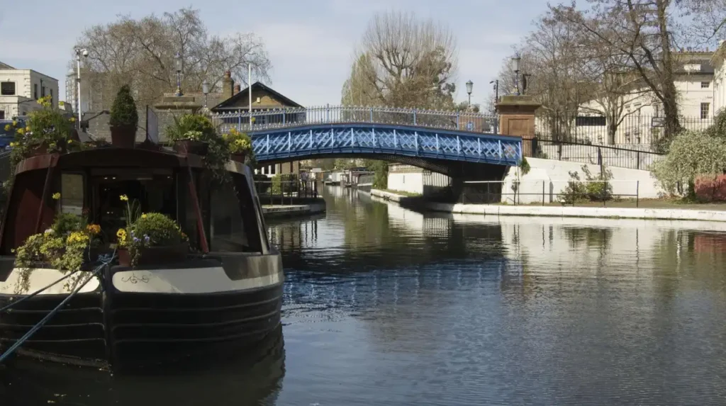
How do canal bridges support West London’s transport network today?
Canal bridges continue to connect West London’s roads, railway lines, footpaths and residential areas. They preserve access across waterways, support walking and cycling, and help maintain the transport connections required by established communities and expanding urban developments.
Although canals no longer carry the same volume of commercial freight they transported during the Industrial Revolution, their bridges remain essential infrastructure.
Road bridges allow local traffic to cross waterways without detours. Railway bridges maintain connections between stations, industrial districts and central London. Pedestrian crossings connect streets, parks and towpaths, making canal corridors accessible to residents.
The continued use of these structures creates maintenance responsibilities. Bridge owners and infrastructure operators must assess structural condition, manage traffic loads and ensure that crossings remain safe for their intended purpose.
How do bridges support walking and cycling?
Canal bridges help pedestrians and cyclists move between neighbourhoods separated by waterways. Towpath crossings provide access to both sides of the canal, while road bridges connect streets that would otherwise terminate at the water.
The Grand Union Canal Quietway provides an example of how the canal corridor supports active travel. Its route links several West London neighbourhoods and destinations, including Brentford, Hanwell, Southall, Hayes and Uxbridge.
However, towpaths have limited widths and were not designed uniformly for modern recreational use. Walkers and cyclists should share the space carefully, reduce speed around blind corners and give other users sufficient room.
How do canal bridges affect local development?
Bridges influence how neighbourhoods connect and develop. A road crossing provides access to businesses, homes and public facilities. A pedestrian bridge can improve access between residential streets and green spaces.
Historic bridges also contribute to the character of conservation areas. Their materials, proportions and relationship with nearby buildings help preserve the visual identity of older canal-side districts.
New developments sometimes require bridge improvements or additional crossings. Planning decisions must consider structural safety, accessibility, landscape character and the effects of construction on canal navigation.
How should visitors plan a canal bridge walk in West London?
Visitors should choose a publicly accessible canal section, identify notable bridges in advance and check towpath conditions before departure. Comfortable footwear, suitable weather clothing and awareness of cyclists, boats, road traffic and railway boundaries support a safer visit.
Planning a canal bridge walk begins with selecting a manageable route. A short visit to Brentford offers access to the canal’s connection with the Thames. Hanwell provides opportunities to explore historic locks and unusual railway engineering. Longer walks connect several neighbourhoods along the Grand Union Canal.
Visitors should consult the Canal & River Trust for route information, navigation notices and towpath guidance before travelling.
What should visitors check before setting out?
Check the route length, available transport connections and any access restrictions. Construction work, maintenance activities, flooding and damaged towpath surfaces sometimes affect walking routes.
Wear footwear suitable for uneven paths. Carry drinking water and check the forecast, particularly during periods of heavy rain or high temperatures.
Canal towpaths are shared spaces. Keep dogs under control, give way when appropriate and avoid blocking narrow sections while taking photographs.
How can visitors observe bridges safely?
View bridges from public towpaths and designated viewing areas. Do not climb bridge parapets, enter railway property or stand in roadways to obtain photographs.
Railway bridges require particular care because trains operate independently of pedestrian movement. Visitors should never enter railway tracks or attempt to access railway infrastructure.
At Three Bridges, observe the arrangement from permitted public viewpoints. The engineering can be understood without entering restricted areas or approaching moving trains.
What should photographers look for?
Photographers can document the relationship between bridge structures, canal water, towpaths and surrounding buildings. Details such as brickwork, iron components, arch profiles and supporting piers reveal differences in construction methods.
Photographs taken from public paths also help record the condition of historic infrastructure over time. When publishing images, provide accurate captions identifying the bridge and its location. Confirm image permissions before using photographs commercially.
Explore More Area Guide
West London Canal Towpaths: Best Walks, History and Visitor Guide
Thames Path in West London: Routes, History and Attractions
How do West London’s canal bridges contribute to heritage and the environment?
Canal bridges preserve evidence of West London’s industrial history while maintaining access to waterways that support recreation and urban wildlife. Their conservation protects historic structures, strengthens local identity and helps retain connections between built heritage and green infrastructure.
The historic value of a canal bridge extends beyond its construction. The structure also records how communities moved goods, crossed waterways and adapted to industrial growth.
Bridges associated with canals, railway docks and former industrial sites help explain the relationship between transport infrastructure and the development of West London.
The environmental value of canal corridors also matters. Waterways provide habitats for aquatic organisms, birds and invertebrates, while towpaths and waterside vegetation form green routes through developed areas.
How do canal bridges contribute to local heritage?
Historic bridges provide physical evidence of engineering methods and industrial activity. Their materials and structural forms help researchers understand the technologies used during different periods.
Listed structures receive formal recognition because of their special architectural or historic interest. Gallows Bridge, for example, is Grade II listed, reflecting its recognised heritage significance.
Conservation also helps communities retain a visible connection with earlier stages of urban development. Historic structures often remain useful long after the industries that originally depended on them have changed.
How do canal corridors support wildlife?
Canals and their banks form linear habitats through urban areas. Aquatic vegetation, waterside plants and nearby trees provide shelter and feeding opportunities for wildlife.
The value of an individual location depends on water quality, vegetation, disturbance and habitat connectivity. A bridge does not automatically create a wildlife habitat, but its surrounding canal corridor forms part of the wider environment.
Visitors can support wildlife by keeping to established paths, avoiding disturbance to nesting birds and disposing of litter responsibly.
Why does bridge conservation matter?
Bridge conservation balances historic preservation with practical requirements such as structural safety and continued public access.
Maintenance work can involve repairing masonry, treating exposed metal, improving drainage and strengthening structural components. Where a bridge is listed or located within a conservation area, relevant heritage requirements influence the work.
The aim is to preserve significant historic features while ensuring that the structure remains suitable for its intended use.
What is the future of canal bridges in West London?
The future of West London’s canal bridges depends on regular structural maintenance, appropriate heritage protection and careful integration with modern transport needs. Continued investment supports safe crossings, accessible towpaths and the preservation of historic engineering within changing urban neighbourhoods.
West London continues to experience redevelopment, changes in travel patterns and growing interest in walking and cycling. Canal bridges form part of the infrastructure needed to connect established neighbourhoods with new homes, workplaces and public spaces.
Historic bridges require particular attention because their original materials and construction methods differ from those used in modern structures. Maintenance programmes must account for corrosion, masonry deterioration, drainage problems and changing traffic demands.
Climate-related pressures also make water management important. Intense rainfall, localised flooding and changing water levels affect the surrounding canal environment and access routes. The precise risks differ between locations and depend on drainage, topography and infrastructure condition.
How will maintenance protect historic bridges?
Regular inspections help identify deterioration before it becomes a serious structural problem. Engineers assess the condition of load-bearing elements, supports, joints, masonry and metalwork.
Maintenance plans also consider the bridge’s intended use. A historic footbridge faces different loading demands from a structure carrying heavy road traffic or railway infrastructure.
Where a bridge has heritage protection, repair methods should respect its significant features. Appropriate materials and specialist conservation techniques help retain historic character while maintaining structural performance.
How can new development protect canal heritage?
Planning authorities, developers and infrastructure operators need to consider canal bridges when proposing nearby construction or transport improvements.
Development should maintain safe access, protect significant views and avoid unnecessary damage to historic structures. Designs that respect the canal’s scale and character help preserve the relationship between the waterway and its surrounding neighbourhood.
The Grand Union Canal and Paddington Arm provide established walking routes and links between communities. Protecting bridge access and towpath continuity supports these functions while retaining the historic importance of the waterways.
Why will canal bridges remain important?
Canal bridges will remain important because they combine practical transport functions with historic and environmental value. They connect roads and footpaths, provide evidence of industrial engineering and form recognisable features of West London’s waterways.
Their continued use demonstrates how infrastructure built for nineteenth-century transport remains relevant to modern urban life.
For residents, visitors and local historians, these structures provide a way to understand the development of Brentford, Hanwell, Southall, Hayes, Uxbridge and Paddington. Protecting them preserves both the physical infrastructure and the history embedded in the canal landscape.
Canal bridges in West London reveal the engineering, transport and industrial history of the Grand Union Canal and Paddington Arm. From the Grade II listed Gallows Bridge in Brentford to the remarkable Three Bridges structure at Hanwell, these crossings demonstrate how engineers accommodated roads, railways and waterways within a changing urban landscape.
The bridges continue to support movement between neighbourhoods while contributing to local heritage and canal-side recreation. Their preservation requires suitable maintenance, responsible public access and planning that respects historic infrastructure.
Visitors can explore these structures through walks around Brentford, Hanwell, Southall, Hayes and Paddington. Each location offers a different perspective on the relationship between West London’s waterways and the communities that developed around them.
What are the most famous canal bridges in West London?
Gallows Bridge in Brentford and Three Bridges in Hanwell are notable canal crossings in West London. Gallows Bridge is a historic iron structure, while Three Bridges combines a road crossing, canal aqueduct and railway route.