

West London’s Thames riverside areas combine historic waterfront settlements, riverside parks, residential neighbourhoods, heritage buildings and walking routes. From uk/local/richmond-upon-thames/richmond/">Richmond and Kew to hounslow/chiswick/">Chiswick, fulham/hammersmith/">Hammersmith, Barnes, Brentford and Isleworth, the River Thames shapes local geography, recreation, transport, conservation and community life.
- What are the main Thames riverside areas in West London?
- How did the River Thames shape West London’s history?
- How did Richmond develop around the Thames?
- Why is Brentford historically important?
- How did royal estates influence the riverside landscape?
- What makes Richmond a leading Thames riverside destination?
- What can visitors explore along the Thames in Kew and Brentford?
- Which Thames riverside areas are best for walking?
- What is the riverside walking experience in Chiswick?
- What makes Barnes suitable for nature-focused walks?
- Where can walkers enjoy the Thames in Isleworth?
- How do Hammersmith and Barnes differ as riverside neighbourhoods?
- What makes Hammersmith’s riverside distinctive?
- Why is Barnes important for wildlife and conservation?
- What historic landmarks can people find beside the Thames in West London?
- What is the historical significance of Ham House?
- Why is Richmond Bridge an important landmark?
- How does West London’s industrial heritage remain visible?
- What wildlife and natural habitats exist along the West London Thames?
- Which riverside locations are useful for birdwatching?
- How do wetlands benefit West London’s environment?
- How does Richmond Park contribute to local biodiversity?
- How does the River Thames influence transport and connectivity in West London?
- Can visitors travel by boat along the Thames in West London?
- How do bridges connect West London’s riverside communities?
- How do riverside parks and public spaces serve local communities?
- How does riverside development affect West London communities?
- Why is flood risk important near the Thames?
- How is environmental protection balanced with new development?
- When is the best time to explore Thames riverside areas in West London?
- Why do Thames riverside areas remain important to West London?
What are the main Thames riverside areas in West London?
Thames riverside areas in West London are neighbourhoods beside the River Thames, extending through historic towns, residential districts and green spaces. Key locations include Richmond, Kew, Brentford, Chiswick, Hammersmith, Barnes, Mortlake, Isleworth, Twickenham and Teddington, each with distinct landscapes and heritage.
The River Thames is a defining geographical feature of West London. It connects communities across several boroughs and provides a setting for public parks, historic buildings, walking routes, leisure facilities and transport connections.
The riverside is not a single continuous type of landscape. Some sections feature paved promenades and busy town centres. Others contain quiet meadows, residential streets, working waterways and protected wildlife habitats.
The London Borough of Richmond upon Thames is particularly closely associated with the river. The Thames runs through the borough and links communities such as Richmond, Kew, Twickenham, Barnes and Teddington. Historic England identifies the river as a major geographical feature in the borough’s historical development.
Brentford and Isleworth provide another important section of the West London waterfront. Brentford developed near the confluence of the River Brent and the Thames, while Isleworth retains riverside open spaces and views towards Richmond Lock.
These areas serve different purposes. Richmond and Chiswick combine town-centre facilities with riverside recreation. Barnes and Kew offer access to natural landscapes and conservation sites. Brentford reflects the relationship between the river, industry, transport and modern urban regeneration.
How did the River Thames shape West London’s history?
The River Thames shaped West London’s history by supporting transport, trade, settlement, agriculture and royal estates. Riverside communities developed around crossings, landing places, mills and working waterfronts, while later industrialisation and suburban growth transformed their economies, architecture and connections with central London.
For centuries, the Thames provided an important route for moving people and goods. Before modern roads and railways became dominant, river transport connected settlements with markets and commercial centres.
The river also influenced where communities formed. Accessible banks supported landing places, ferries, bridges and commercial activity. Settlements grew near crossings and the points where tributaries entered the main river.
How did Richmond develop around the Thames?
Richmond developed from a settlement with royal connections into a major riverside town. The surrounding landscape attracted royal residents, estate owners and visitors, while the river contributed to the area’s recreational and commercial character.
Richmond Park provides evidence of the area’s royal history. The Royal Parks records that King Charles I established Richmond Park as a royal hunting ground in 1637, following his move to Richmond in 1625. The park retains historic woodland, open grassland and herds of red and fallow deer.
The town’s historic riverfront subsequently became associated with public recreation, hospitality and tourism. Richmond Riverside now includes seating, terraced lawns and access to nearby restaurants and bars.
Why is Brentford historically important?
Brentford is historically important because it developed around the meeting point of the River Brent and the Thames. Its riverside location supported settlement, transport and commercial activity, connecting the area with wider regional networks.
Historic England identifies Brentford’s historic core as an archaeological priority area. The area includes evidence associated with Roman, medieval and post-medieval settlement, alongside the Thames foreshore and the probable route of a Roman road.
The area’s industrial past remains relevant to its present-day identity. Former commercial and industrial waterfronts now sit alongside residential developments, public spaces and leisure facilities.
How did royal estates influence the riverside landscape?
Royal estates influenced West London’s riverside landscape through the development of palaces, formal gardens, parks and managed countryside. Historic properties such as Ham House, Kew Palace and Hampton Court Palace illustrate different periods of royal and aristocratic influence.
These estates helped preserve historic buildings and landscapes that remain important to the region’s cultural identity. Their surviving grounds also provide green space and support public access to heritage and horticulture.
What makes Richmond a leading Thames riverside destination?
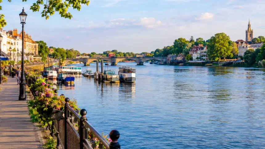
Richmond is a leading Thames riverside destination because it combines a prominent waterfront, historic bridges, restaurants, public gardens and access to extensive parkland. Richmond Riverside provides a central gathering space, while Richmond Park, Petersham Meadows and nearby historic houses extend the area’s outdoor and heritage attractions.
Richmond’s riverside is one of the area’s most recognisable public spaces. The waterfront is close to the town centre, making it accessible for residents, commuters and visitors.
Richmond Riverside, near Heron Square, includes terraced lawns and seating overlooking the river. Its location near restaurants and bars makes it suitable for short walks, outdoor breaks and meeting friends. The council confirms that the open space is accessible at all times.
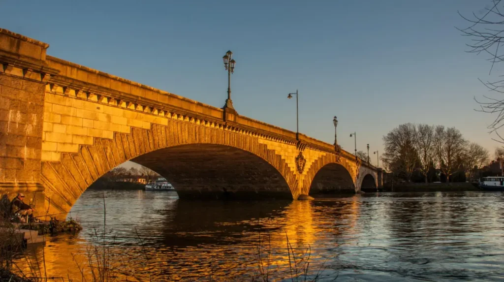
Richmond Bridge is another important local landmark. The historic crossing connects the two sides of the river and provides a focal point for views along the waterfront.
What outdoor attractions are near Richmond Riverside?
Outdoor attractions near Richmond include Richmond Park, Petersham Meadows and Terrace Gardens. These locations offer different landscapes, ranging from open grassland and woodland to formal gardens and river-facing viewpoints.
Richmond Park is London’s largest Royal Park and has been designated a National Nature Reserve and a Site of Special Scientific Interest. Its habitats support deer, birds, invertebrates, fungi and wildflowers.
Petersham Meadows provides a more open riverside landscape, while Terrace Gardens offers landscaped paths and planting above the town’s waterfront.
Visitors should distinguish between the riverside itself and nearby attractions. Richmond Park is a substantial walk from some parts of the riverfront, so exploring both requires additional time.
How does Richmond support riverside tourism?
Richmond supports riverside tourism through its combination of historic landmarks, independent shops, food venues, public transport and outdoor attractions. Visitors can explore the waterfront, walk towards Petersham or connect a river visit with gardens and historic houses.
Boat trips and river-based leisure activities also contribute to the area’s visitor economy. Routes and operating arrangements vary, so travellers should check current services before planning a journey.
What can visitors explore along the Thames in Kew and Brentford?
Kew and Brentford offer contrasting Thames experiences, combining botanical heritage, historic transport infrastructure, urban waterfronts and access to green spaces. Kew is best known for its internationally significant botanical gardens, while Brentford reflects the historic relationship between the Thames, the River Brent, commerce and urban development.
Kew lies on the southern side of the Thames, between Richmond and Brentford. Its riverside setting is closely associated with the Royal Botanic Gardens, Kew, a major centre for plant science, horticulture and botanical conservation.
The gardens contain extensive plant collections, historic buildings and landscaped grounds. Historic England identifies Kew Gardens as an important historic landscape with roots in the early eighteenth century.
Kew’s identity extends beyond the gardens. Residential streets, historic railway infrastructure and riverside paths connect the neighbourhood with surrounding communities.
Brentford occupies a different position in West London’s river geography. Its connection with the River Brent made the settlement significant for transport and commerce, and its waterfront continues to reflect the relationship between historic industry and modern development.
Why is Kew Gardens important to the Thames area?
Kew Gardens is important because it combines botanical research, plant conservation, historic architecture and public education within a major landscaped estate. Its riverside setting forms part of the wider cultural and environmental identity of West London.
The Royal Botanic Gardens, Kew, supports scientific research into plant diversity and conservation. Its living collections and scientific resources contribute to understanding plant species, ecosystems and threats to biodiversity.
Kew Palace and other historic structures also demonstrate the area’s royal connections. Together, the gardens and historic buildings make Kew a significant destination for visitors interested in nature, science and heritage.
The gardens are not simply an open riverside park. Admission arrangements, opening hours and access restrictions apply, so visitors should consult the official Kew website before travelling.
What can people see along Brentford’s waterfront?
Brentford’s waterfront includes river views, historic waterways, residential developments and public spaces. The meeting of the River Brent and the Thames provides an important geographical feature, while nearby heritage sites help explain the area’s long history of settlement and commerce.
Brentford Lock and the Grand Union Canal are relevant to understanding the area’s wider waterway network. The canal connects inland locations with the Thames and illustrates how waterways supported goods movement and industrial growth.
Modern development has introduced new residential buildings and public spaces along parts of the waterfront. These changes have reshaped former industrial areas while retaining the river as a central element of local geography.
Which Thames riverside areas are best for walking?
The best Thames riverside areas for walking depend on the desired landscape, distance and facilities. Richmond offers a town-centre waterfront, Chiswick provides residential riverside paths, Barnes connects walkers with wetland habitats, and Isleworth features open riverside spaces near Richmond Lock and the surrounding bridges.
Walking along the Thames provides access to public spaces, historic buildings, bridges and changing views of the river. Routes vary from short promenades to longer sections of the Thames Path, a national trail following the river between its source and the Thames Barrier.
In West London, path conditions and the character of the route vary by location. Some sections use paved promenades and public footpaths, while others pass through natural areas or narrow riverside streets.
Walkers should check local access information before setting out, particularly where routes cross private land, pass through parks with specific opening rules or approach tidal sections.
What is the riverside walking experience in Chiswick?
Chiswick offers a residential riverside environment with historic houses, green spaces, pubs and views across the Thames. Its waterfront is associated with Chiswick Mall, a historic street beside the river, and nearby Chiswick House and Gardens.
Chiswick Mall contains historic houses whose position reflects the area’s long relationship with the river. The waterfront differs from Richmond’s central promenade because much of its character comes from residential architecture and quieter stretches of riverbank.
Nearby Chiswick House and Gardens adds an important heritage attraction. The eighteenth-century villa and landscaped grounds provide a separate destination for visitors exploring the wider neighbourhood.
Public access varies along the waterfront, so visitors should follow marked paths and respect residential property boundaries.
What makes Barnes suitable for nature-focused walks?
Barnes is suitable for nature-focused walks because it combines Thames scenery with wetlands, open spaces and opportunities to observe wildlife. The London Wetland Centre, managed by the Wildfowl & Wetlands Trust, provides a dedicated setting for wetland conservation and environmental education.
The centre contains wetland habitats designed to support birds and other wildlife. Visitors can explore paths, observation areas and nature-focused displays within a managed conservation setting.
The wider Barnes area also offers access to riverside views and residential streets. Its character contrasts with busier commercial waterfronts because nature conservation is a central part of the visitor experience.
The London Wetland Centre is a managed attraction rather than unrestricted public parkland. Visitors should check current admission prices, opening times and accessibility details before arriving.
Where can walkers enjoy the Thames in Isleworth?
Isleworth provides riverside walking opportunities through open spaces near the Thames and Richmond Lock. Isleworth Promenade is a council-managed riverside area with seating, grass and views towards the river and nearby bridges.
The promenade leads towards the Richmond Lock and Weir footbridge, making it a useful location for short walks and viewing the river infrastructure. The council lists St Margarets as the nearest railway station and identifies local bus connections.
The area is suited to visitors who want a quieter riverside setting without concentrating their visit on a major tourist attraction. Conditions can change near the river, so walkers should remain on authorised routes and take care around water and lock structures.
How do Hammersmith and Barnes differ as riverside neighbourhoods?
Hammersmith and Barnes occupy different positions in West London’s riverside landscape. Hammersmith combines a busy commercial centre, transport connections and historic bridges, while Barnes has a more residential character, with village-style streets, wildlife habitats and access to the London Wetland Centre and quieter stretches of the Thames.
Hammersmith is an important riverside centre in the London Borough of Hammersmith and Fulham. Its waterfront sits close to shops, restaurants, offices and major transport connections, making the area accessible to people travelling from other parts of London.
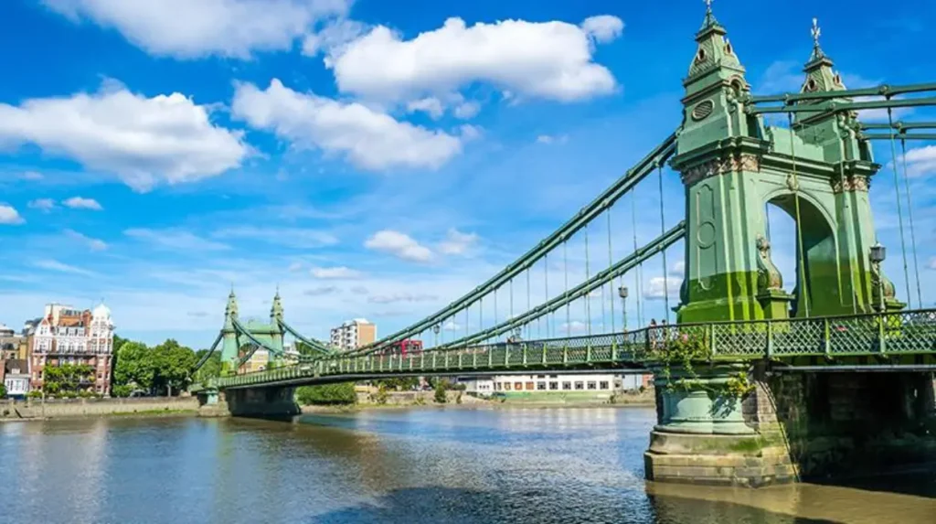
Hammersmith Bridge is a distinctive landmark. The suspension bridge connects Hammersmith with Barnes and has played an important role in local movement across the river. Its operational status and access arrangements have changed over time, so visitors should check current official information before planning to cross it.
Barnes, on the opposite bank, has a different pattern of development. Its residential streets, village centre and green spaces provide a setting for walking, birdwatching and local recreation.
What makes Hammersmith’s riverside distinctive?
Hammersmith’s riverside combines historic infrastructure, commercial activity and public access to the water. The Thames Path passes through the wider area, connecting the waterfront with neighbouring districts and longer walking routes.
The Hammersmith waterfront is associated with traditional riverside pubs, restaurants and views towards the bridges. The area also hosts rowing activity, reflecting the Thames’s long-standing importance for water sports in West London.
Hammersmith’s transport connections make it a practical starting point for exploring the river. Underground services connect the district with central London and other neighbourhoods, while buses provide additional links across West London.
Why is Barnes important for wildlife and conservation?
Barnes is important for wildlife and conservation because the London Wetland Centre protects and presents wetland habitats in an urban setting. Managed by the Wildfowl & Wetlands Trust, the centre provides facilities for wildlife observation, environmental education and habitat management.
Wetlands support birds, aquatic invertebrates, amphibians and other organisms. They also contribute to water storage and the ecological functioning of river landscapes.
The London Wetland Centre gives visitors opportunities to learn about wetland ecology without travelling far from central London. Its managed habitats complement the Thames’s wider natural environment, where wildlife depends on water quality, vegetation and suitable feeding and nesting areas.
What historic landmarks can people find beside the Thames in West London?
Historic Thames landmarks in West London include Richmond Bridge, Kew’s royal and botanical heritage, Chiswick’s historic riverside houses, Ham House, and the waterways around Brentford. These places illustrate the river’s influence on royal estates, residential architecture, trade, transport and the development of local communities.
The Thames corridor contains buildings and landscapes from different historical periods. Medieval settlement patterns, royal estates, eighteenth-century architecture, Victorian transport infrastructure and modern regeneration projects all contribute to the area’s character.
Historic England’s local heritage records document buildings and archaeological sites throughout Richmond upon Thames and Hounslow. These records help explain how the river supported settlement and how later development changed the waterfront.
What is the historical significance of Ham House?
Ham House is a seventeenth-century riverside mansion near Richmond. The National Trust manages the property, which is recognised for its historic interiors, gardens and connections with aristocratic life during the Stuart period.
Historic England records that Ham House was built in the early seventeenth century for Sir Thomas Vavasour and later expanded and remodelled under the Earl of Lauderdale. Its surviving architecture and gardens provide evidence of changing domestic tastes and estate management.
The house is set back from the river within a historic landscape. Its significance therefore extends beyond the building itself to the relationship between the mansion, gardens and surrounding grounds.
Why is Richmond Bridge an important landmark?
Richmond Bridge is important because it provides a historic crossing of the Thames and serves as a focal point for the town’s riverside landscape. Its position links Richmond’s commercial centre with the residential areas on the opposite bank.
Bridges influence riverside development by concentrating movement around specific crossing points. They connect local streets, shape walking routes and help establish the location of shops and services.
Richmond Bridge also contributes to the area’s heritage identity. Views of the bridge and the surrounding waterfront form part of the visitor experience, while its crossing function connects the two sides of the town.
How does West London’s industrial heritage remain visible?
West London’s industrial heritage remains visible through former commercial waterfronts, canal infrastructure, historic bridges and the layout of established settlements. Brentford is a particularly relevant example because its development was closely connected with the River Brent and the Thames.
The Grand Union Canal and its connection with the Thames demonstrate the importance of inland waterways for moving goods. Industrial sites and transport infrastructure supported employment and commercial growth before many riverside districts shifted towards residential and service-based economies.
Modern regeneration has introduced new housing and public spaces into some former industrial areas. The result is a landscape where historical infrastructure sits alongside contemporary buildings and leisure facilities.
What wildlife and natural habitats exist along the West London Thames?
Wildlife and natural habitats along the West London Thames include wetland areas, riverside grassland, reed beds, mature trees and managed parkland. Barnes Wetland Centre, Richmond Park, Petersham Meadows and river margins provide different habitats, supporting birds, aquatic organisms, pollinators and other wildlife.
The Thames is both a waterway and an ecological corridor. Its natural functions depend on water quality, riverbank vegetation, connected habitats and the management of surrounding land.
West London’s riverside environment varies considerably. Urban embankments and paved promenades offer less habitat than wetlands and areas with natural vegetation. However, parks, gardens and restored habitats contribute to biodiversity within the wider urban landscape.
Which riverside locations are useful for birdwatching?
Barnes Wetland Centre is a dedicated destination for birdwatching, while Richmond Park and suitable riverside green spaces offer additional opportunities to observe birds. Wetlands, ponds and vegetated river margins provide feeding and resting areas for different species.
Birdwatchers can observe waterbirds, garden birds and other species depending on the habitat and season. The types of birds present change throughout the year because some species migrate while others remain resident.
Visitors should use designated viewing points, avoid disturbing nesting birds and follow the rules of managed nature reserves. Binoculars and a field guide help identify species without approaching wildlife too closely.
How do wetlands benefit West London’s environment?
Wetlands benefit West London’s environment by providing wildlife habitat, storing water and supporting natural ecological processes. Wetland vegetation also captures nutrients and sediment, while wetland soils store organic carbon under suitable conditions.
The London Wetland Centre demonstrates how wetland habitats can be managed and presented within a densely populated urban region. Its educational role helps visitors understand the relationship between biodiversity, water management and urban development.
Wetlands do not eliminate flood risk, and their performance depends on their size, condition and connection to the wider catchment. However, healthy wetland landscapes form part of broader approaches to managing water and protecting biodiversity.
How does Richmond Park contribute to local biodiversity?
Richmond Park contributes to local biodiversity through its ancient woodland, grassland, ponds and long-established deer populations. The Royal Parks identifies it as a National Nature Reserve and a Site of Special Scientific Interest, reflecting its ecological importance.
The park also supports insects, fungi, wildflowers and birds. Its range of habitats makes it ecologically different from the built-up riverfront in Richmond town centre.
Although Richmond Park is not entirely beside the river, it forms part of the wider landscape that makes this section of West London distinctive. Visitors can combine a riverside visit with a separate excursion into the park.
How does the River Thames influence transport and connectivity in West London?
The River Thames influences West London transport through historic bridges, pedestrian crossings, river services and connections with surrounding roads and railways. Richmond, Hammersmith, Kew, Brentford and Isleworth each provide access to different transport networks, while river crossings connect neighbourhoods on opposite banks.
The Thames creates both connections and physical barriers. Bridges and ferries help people cross the river, while riverside paths support walking and cycling along selected stretches.
Railway stations and Underground services connect many riverside neighbourhoods with central London. Bus networks also serve residential districts and local attractions, although the nearest station and most convenient route differ by destination.
Can visitors travel by boat along the Thames in West London?
Visitors can use scheduled river services and leisure boats on selected sections of the Thames, subject to current routes and operating arrangements. Services in the wider Richmond area connect riverside destinations with other parts of the river network.
River travel provides a different way to view bridges, historic buildings and waterfront landscapes. However, not every riverside neighbourhood has a regular passenger pier, and boat services do not operate with the same frequency as urban rail networks.
Visitors should check the operator’s official timetable, departure pier, ticket conditions and seasonal schedule before travelling. They should also confirm that the service stops at their intended destination rather than assuming every boat calls at every riverside town.
How do bridges connect West London’s riverside communities?
Bridges connect communities by providing routes for pedestrians, cyclists, public transport and road traffic. Richmond Bridge, Hammersmith Bridge and other crossings help link neighbourhoods that would otherwise require a longer journey around the river.
Each crossing has different access arrangements. Restrictions, maintenance work and temporary closures affect journey planning, particularly for people travelling on foot or by bicycle.
Checking current bridge access is important when planning a walk between Hammersmith and Barnes or exploring both sides of the river near Richmond. A riverside route that looks continuous on a map does not always provide a direct crossing at the nearest point.
How do riverside parks and public spaces serve local communities?
Riverside parks and public spaces in West London provide places for walking, exercise, relaxation, social activities and contact with nature. Richmond Riverside, Isleworth Promenade, landscaped gardens and accessible sections of the Thames Path serve residents and visitors, while managed wetlands and larger parks support conservation and outdoor education.
Public spaces make the Thames accessible beyond private homes, commercial premises and ticketed attractions. Seating, lawns, walking paths and viewing areas allow people to experience the waterfront without participating in organised activities.
The facilities vary between locations. Richmond Riverside offers seating and terraced lawns near restaurants, while Isleworth Promenade provides grass, seating and views towards Richmond Lock. Both are identified as accessible public spaces by the local council.
What activities are available along the river?
Common riverside activities include walking, running, cycling on suitable paths, photography, birdwatching and visiting nearby heritage attractions. Examples include a short walk around Richmond Riverside, a nature visit to Barnes Wetland Centre or a longer route through Chiswick.
Rowing and other water sports are also part of the Thames’s recreational use. Activities depend on local facilities, river conditions and the rules governing access to the water.
Families should choose routes that match children’s ages and walking abilities. Visitors should also consider toilets, refreshments, step-free access and public transport when planning a longer outing.
How accessible are West London’s riverside areas?
Accessibility varies by route, park and attraction. Some waterfronts have level paths and seating, while older streets, steps, uneven surfaces and restricted crossings create barriers in other locations.
Public transport availability also affects accessibility. A neighbourhood with a nearby railway station can still require a substantial walk to reach a particular section of the river.
Visitors who need step-free access should check official information for individual parks, attractions and transport services. They should not assume that the entire Thames Path or every historic riverside street is suitable for wheelchairs and mobility aids.
How does riverside development affect West London communities?
Riverside development affects West London through housing growth, commercial investment, public-space improvements, heritage conservation and pressure on transport and infrastructure. Brentford illustrates the transformation of former industrial waterfronts, while Richmond and Chiswick demonstrate the importance of protecting historic landscapes and maintaining public access to the Thames.
The riverfront attracts residential and commercial development because of its location, views and recreational opportunities. Former industrial land provides opportunities for redevelopment, particularly where older commercial uses have declined.
However, riverside development requires careful planning. New buildings must respond to flood risk, transport capacity, environmental protection and the character of existing neighbourhoods.
Why is flood risk important near the Thames?
Flood risk is important because the Thames and its tributaries interact with rainfall, river levels, drainage systems and tidal conditions. Different locations face different combinations of fluvial flooding, tidal flooding and surface-water flooding.
The Environment Agency provides flood-risk information for England, including information about river and sea flooding. Property owners, residents and visitors should consult official flood maps and warnings when assessing a particular location.
A riverside address does not automatically mean a property is at high risk, and being outside a mapped flood zone does not eliminate every form of flood risk. Assessments need to consider the precise location, building characteristics and relevant flood mechanisms.
How is environmental protection balanced with new development?
Environmental protection is balanced with development through planning policies, ecological assessments, heritage controls and measures to manage flood risk. Projects near sensitive habitats or historic buildings require attention to their potential effects on the surrounding environment.
Riverside planning also considers public access. New developments can include walking routes, landscaped spaces and connections to existing paths, helping communities reach the riverfront.
The challenge is to accommodate housing and economic activity without damaging biodiversity, increasing flood exposure or removing the historic features that give West London its identity.
Explore More Area Guide
Rivers in West London: Thames, Brent, Crane & Colne Guide
Butterfly Watching in West London Best Parks and Nature Reserves
When is the best time to explore Thames riverside areas in West London?
The best time to explore Thames riverside areas depends on the planned activity, weather, daylight and attraction opening hours. Spring and summer suit longer walks and outdoor visits, autumn offers seasonal landscape changes, and winter provides quieter routes, although daylight is shorter and conditions require additional care.
Spring brings longer daylight hours and renewed plant growth. It is suitable for exploring gardens, observing seasonal wildlife and walking through parks.
Summer generally provides more opportunities for outdoor dining, riverside photography and longer walks. Popular waterfronts can become busy during weekends and favourable weather, so early starts provide a quieter experience.
Autumn brings changing foliage and seasonal wildlife activity. Winter offers a different view of the river landscape, but rain, wind and reduced daylight can make longer routes less convenient.
River levels, weather and tidal conditions can change independently of the season. Visitors should check local conditions before walking close to the water or planning a boat trip.
How should visitors plan a riverside day out?
Visitors should select a main destination, check transport connections and identify nearby attractions before setting out. A practical day trip can focus on Richmond’s waterfront and gardens, Barnes and its wetland habitats, or the historic waterways around Brentford.
A short visit works best when the main attraction is close to the chosen station or bus stop. Longer outings require additional planning for refreshments, walking distances, accessibility and return transport.
Visitors should check official attraction websites for admission arrangements and seasonal opening hours. They should also confirm the availability of river services and bridge crossings if these form part of the itinerary.
Why do Thames riverside areas remain important to West London?
Thames riverside areas remain important to West London because they connect historic settlements, public spaces, transport infrastructure, residential communities and wildlife habitats. Richmond, Kew, Chiswick, Hammersmith, Barnes, Brentford and Isleworth demonstrate how the river continues to shape local identity, recreation, conservation and urban development.
The Thames is more than a geographical boundary. It is a shared landscape that connects neighbourhoods with different histories, architectural styles and environmental characteristics.
Richmond combines a prominent waterfront with royal heritage and extensive parkland. Kew connects botanical science and historic gardens with the river landscape. Brentford reflects the relationship between waterways and commerce, while Hammersmith and Barnes demonstrate contrasting forms of urban and nature-focused riverside life.
Chiswick contributes historic residential architecture and quieter waterfront routes. Isleworth offers public riverside spaces near important river infrastructure. Together, these places show the variety of experiences available along West London’s section of the Thames.
The river’s future importance depends on maintaining safe public access, protecting wildlife, managing flood risk and conserving historic landscapes. Responsible planning and environmental management help ensure that the Thames continues to serve local communities while retaining its ecological and cultural value.
For residents, the waterfront provides everyday opportunities for walking, exercise and outdoor recreation. For visitors, it offers access to historic landmarks, gardens, wildlife sites and distinctive neighbourhoods. These combined roles make the Thames one of the defining features of West London.
Which are the main Thames riverside areas in West London?
The main Thames riverside areas in West London include Richmond, Kew, Chiswick, Hammersmith, Barnes, Brentford, Isleworth, Mortlake, Twickenham and Teddington. Each area offers a different combination of historic landmarks, residential streets, riverside walks and green spaces.