

Key Points
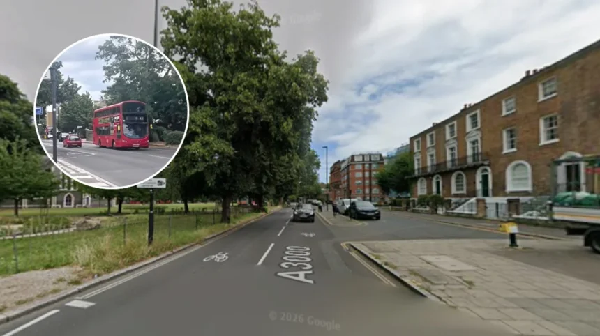
- A six-week public consultation has been launched by Transport for London (TfL) on their latest proposals to extend Cycleway 9 from Syon Park all the way to Hounslow Town Centre.
- These proposals include the creation of continuous segregated cycleways, improved pedestrian crossings, side road junction improvements, expanded pavements, and other features on London Road and High Street.
- The objective behind this project is to build a network of cycleways connecting Hammersmith, Chiswick, Kew Bridge, Brentford, and Hounslow to future connections with Cycleway 40.
- The modifications will involve moving 18 bus stops, the demolition of four bus stops (Beech Avenue bus stop in the eastbound direction and stop J next to Star Road), and the closing of Epworth Road junction to all motor vehicles.
- According to the traffic model used by TfL, peak period delays due to general traffic will be increased by up to 2 minutes for eastbound movement and 3 minutes for westbound movement; while buses will take an extra 100 seconds during their westbound movements.
- The public consultation will continue until 19 October, and there will be two drop-in sessions held at West Thames College on 23 September and 10 October.
London (West London Times) September 8, 2026 – Transport for London (TfL) has published its long-awaited proposals to extend Cycleway 9 westwards from Syon Park to uk/local/hounslow/">Hounslow Town Centre, setting out a comprehensive package of changes to London Road and the High Street. As reported on BrentfordTW8.com, the initiative aims to reshape one of west London’s busiest corridors for pedestrians, cyclists, and public transport users alike.
- Key Points
- How Will the Route Be Structured Across the Corridor Sections?
- Which Bus Stops and Traffic Management Measures Are Affected?
- What Impact Will the Scheme Have on Traffic Delays and Tree Canopies?
- How Can Residents Participate in the Consultation Process?
- Background of the Particular Development
The six-week public consultation marks a major step forward for the transport project, which is anticipated to draw a high volume of responses from local residents, businesses, and regular commuters. The overarching objective of the scheme is to introduce continuous segregated cycle tracks, upgraded pedestrian crossings, redesigned side-road junctions, widened footways, and modern infrastructure across the full length of the Syon Park-to-Hounslow corridor.
According to official planning details outlined on BrentfordTW8.com, the new route commences in the east at Beech Avenue. The plans follow earlier infrastructure projects delivered east of Beech Avenue by Hounslow Council. However, a physical gap in the cycling network currently exists at Alexandra Road east of Brentford centre, and the consultation report for that specific intermediate segment has not yet been formally published.
The publication notes a specific administrative omission in the current consultation papers: BrentfordTW8.com stated,
“The consultation papers do not mention this gap in provision and we have asked TfL if Cycleway 9 West is contingent on the section through Brentford being completed or if it will be progressed regardless.”
How Will the Route Be Structured Across the Corridor Sections?
Across the length of the targeted corridor, TfL has laid out detailed interventions tailored to individual segments, ranging from Beech Avenue to Busch Corner, continuing through to Langley Road, St John’s Road, Spring Grove, Honnor Gardens, Star Road, Richens Close, Alderwick Drive, Kingsley Road, and onward through the High Street to the School Road and Laurence Road junction.
The proposed engineering works encompass several specific structural adjustments:
- Segregated Tracks: The creation of new protected cycle tracks on both sides of London Road, featuring a two-way track introduced west of Sidmouth Avenue.
- Junction Treatments: The incorporation of raised side-road entry treatments designed to slow turning motor vehicles and offer pedestrians a level surface for crossing.
- Crossing Enhancements: The rollout of upgraded crossings, which include new parallel crossings for pedestrians and cyclists, widened zebra crossings, and new signal-controlled crossings positioned strategically outside local shops and educational institutions.
- Bus Stop Bypasses: The implementation of bus stop bypasses at multiple locations, allowing cyclists to safely pass behind waiting passengers via “mini zebra crossings” designed to assist foot passengers accessing the stops.
Which Bus Stops and Traffic Management Measures Are Affected?
While active travel advocates generally welcome enhanced cycling infrastructure, significant alterations to local transport logistics are expected to spark debate. TfL’s proposal includes plans to relocate 18 bus stops and completely remove four, including the eastbound stop at Beech Avenue and bus stop J near Star Road. Furthermore, the removal of the westbound Bridge Road bus stop will increase the spacing between remaining stops to roughly 500 metres, a change that could pose accessibility challenges for passengers with mobility limitations or those who depend heavily on frequent local transit spacing.
Vehicle and traffic management measures also form a core part of the blueprint. The scheme mandates the closure of the Epworth Road junction to motor traffic, alongside the removal of existing traffic islands located at Amhurst Gardens and Bridge Road. These modifications could alter local traffic patterns and influence turning movements across adjacent residential streets.
In addition, parking and loading arrangements will shift. Several bays are slated for removal—including six spaces situated outside Warren Motors in Isleworth—while other bays will be expanded or repositioned. Local businesses operating along London Road and the High Street may scrutinize these changes regarding customer footfall, parking availability, and logistics for commercial deliveries.
What Impact Will the Scheme Have on Traffic Delays and Tree Canopies?
Transport for London’s predictive traffic modelling indicates that the implementation of Cycleway 9 West will lead to increased peak-time delays for general motorists and bus services alike. General traffic delays are projected to rise by up to 2 minutes eastbound and up to 3 minutes westbound. Meanwhile, local bus services could experience increased journey times of up to 100 seconds westbound and under a minute eastbound. Nevertheless, TfL cautions that actual journey conditions may fluctuate due to day-to-day traffic variations.
Environmental considerations have also surfaced in the plans. TfL acknowledges that a number of trees will require removal to accommodate the footprint of the new cycle tracks. Although the transport authority has promised to seek out opportunities for replacement planting in nearby areas, tree loss remains a sensitive subject in urban planning consultations, especially in neighbourhoods facing limited existing canopy cover.
Regarding bi-directional track layouts, historical feedback from earlier phases of the network has noted mixed reactions. Supporters appreciate the clear separation they provide, whereas critics raise concerns regarding potential conflict points at side roads and intersections where line-of-sight visibility may be constrained. TfL has indicated it is actively introducing mitigation steps to address safety challenges identified on previous sections of the route.
Explore more Hounslow News:
Gunnersbury Park Concerts Approved Despite Hounslow Meeting Row 2026
Hounslow Approves 111 Homes With Zero Affordable Housing Isleworth 2026
How Can Residents Participate in the Consultation Process?
Transport for London has organized two formal drop-in sessions at West Thames College, scheduled for 23 September and 10 October, giving local stakeholders an opportunity to engage directly with TfL representatives. Feedback on the scheme can be submitted via online channels, email, telephone, or postal correspondence. The public consultation remains active, with a strict closing deadline of 19 October for all final submissions.
Background of the Particular Development
Cycleway 9 is a flagship protected cycling infrastructure project spearheaded by Transport for London, originally conceived to establish a continuous, protected transit corridor linking fulham/hammersmith/">Hammersmith, Chiswick, Kew Bridge, and Brentford. Over recent years, major eastern segments—including parts of Chiswick High Road and the Kew Bridge-to-Watermans Park stretch—have been completed and opened to the public, while Hounslow Council has progressed independent sections extending toward Alexandra Road.
The current push to introduce Cycleway 9 West represents the final planned western phase of this strategic transit corridor. Strategically, the route is designed to integrate into a wider west London transport network, including potential future connections with Cycleway 40, which aims to link Old Isleworth and Twickenham. The project aligns with broader regional transport targets aimed at encouraging active travel, cutting carbon emissions, and reducing private vehicle dependency across outer London boroughs.
The development of Cycleway 9 West carries significant implications for local residents, small business owners, cyclists, and public transport commuters in Brentford, Isleworth, and Hounslow. For cyclists and pedestrians, the introduction of continuous segregated tracks and upgraded crossings is projected to dramatically improve road safety and encourage higher rates of active commuting along a historically congested and hazardous arterial route.
Conversely, local motorists and bus passengers face the prospect of increased peak-hour journey times and altered bus stop proximities, which could present daily commuting challenges for elderly or mobility-impaired residents. Furthermore, local traders and high street shop owners may experience adjustments in customer accessibility and delivery logistics due to the reconfiguration of parking bays and loading restrictions. Ultimately, the success of the consultation and subsequent construction phases will depend heavily on how effectively TfL balances active travel objectives against vehicular flow and local commercial vitality.