

West London has transformed from a landscape of rural villages, farmland and riverside settlements into one of Greater London’s most diverse and economically important areas. Its history reflects the expansion of the British capital, the development of railway networks, industrial growth, international migration, changing housing patterns and large-scale urban regeneration.
- What Was West London Like Before the Industrial Revolution?
- How Did Roman Britain Influence the Development of West London?
- How Did West London Develop During the Medieval Period?
- Why Did West London Become Popular With Wealthy Londoners?
- How Did the Industrial Revolution Transform West London?
- How Did Victorian Railways Change West London?
- What Role Did the Thames Play in West London’s Economic History?
- How Did West London Change During the Early Twentieth Century?
- How Did World War II Affect West London?
- How Did Immigration Shape West London’s Communities After 1945?
- How Did West London’s Housing and Architecture Evolve?
- How Did Heathrow Airport Influence West London’s Growth?
- How Did West London Develop During the Late Twentieth Century?
- How Is West London Changing in the Twenty-First Century?
- What Makes West London’s Neighbourhoods Historically Distinct?
- Why Does West London’s History Matter for Future Development?
- How Can Residents Explore West London’s History Today?
- Conclusion: How Has West London Transformed Through the Decades?
The area includes historic districts such as Kensington, Chelsea, uk/local/hammersmith-and-fulham/hammersmith/">Hammersmith, Fulham, Ealing, hounslow/chiswick/">Chiswick, Acton, Brentford, Hounslow and Richmond. Each location has developed its own identity while remaining connected to London’s wider economic, cultural and political history.
West London’s transformation did not happen in a single period. Roman roads, medieval villages, royal estates, Victorian railways, twentieth-century industry and modern transport infrastructure each influenced its development. Understanding these changes explains why West London combines historic streets, traditional markets, Victorian housing, major commercial centres and contemporary residential developments.
What Was West London Like Before the Industrial Revolution?
Before the Industrial Revolution, West London consisted largely of rural settlements, agricultural land, market villages and estates connected to central London by roads and the River Thames. Communities depended on farming, local trade, river transport and activities serving the capital, while settlement patterns remained concentrated around villages, churches, markets and important routes.
For centuries, much of the land west of the City of London remained outside the densely built-up urban area. Villages developed around agricultural production, religious institutions, estates and roads leading towards Windsor, Oxford and other destinations.
The River Thames played a major role in the area’s early development. Settlements such as Brentford and Chiswick benefited from riverside access, which supported transport, fishing, commerce and communication. The river also connected local communities with central London and other settlements along its course.
Brentford developed as an important crossing point on the western approaches to London. Its location near the Thames and the River Brent supported movement between Middlesex and areas south of the river. The settlement’s historical importance continued as roads, canals and later railways improved regional connectivity.
Kensington and Chelsea developed differently from the agricultural settlements farther west. Their proximity to London made them attractive locations for estates, gardens and residential development. Over time, wealthy residents established houses and gardens in areas that were still relatively separate from the crowded centre of the capital.
Ealing retained a rural character for much of its early history. Its development centred on village life, farmland, churches and roads connecting it with London. Hammersmith and Fulham also contained agricultural land and riverside settlements, although their closeness to the capital encouraged commercial activity.
These early settlement patterns established the foundations of modern West London. Roads, parish boundaries, historic estates and village centres continued to influence where later housing, shopping districts and transport infrastructure developed.
How Did Roman Britain Influence the Development of West London?
Roman Britain influenced West London through regional roads, settlement networks and connections with Londinium, the Roman settlement that developed into modern London. Roman occupation began after the invasion of Britain in AD 43, and the wider region became connected to military, administrative and commercial routes serving the growing provincial capital.
Londinium developed as a significant Roman settlement near the River Thames. Its growth encouraged the development of roads and communication networks connecting London with other parts of Roman Britain.
The wider western approaches to London formed part of this regional network. Roads helped move people, goods and military resources between settlements, although the precise course of some ancient routes and their relationship with later roads remain subjects of archaeological study.
Roman influence was not limited to major urban centres. Rural settlements across the surrounding region participated in agricultural production, trade and transport. However, the archaeological evidence for individual West London districts varies, so the history of Roman activity should not be treated as identical across Kensington, Ealing, Hounslow and Richmond.
Following the end of Roman administration in Britain during the early fifth century, settlement patterns changed. Some Roman urban centres declined, while rural communities and new political structures shaped the subsequent landscape.
The significance of this period lies in its contribution to the wider regional geography. London’s position as a transport and administrative centre continued to influence settlement and economic activity long after Roman rule ended.
West London’s later roads and settlements developed through many different periods. Roman infrastructure formed part of the area’s broader historical background rather than a direct explanation for every modern street or neighbourhood.
How Did West London Develop During the Medieval Period?
During the medieval period, West London developed through parish communities, agricultural estates, market activity and religious institutions. Villages such as Ealing, Hammersmith, Chiswick and Brentford supported local populations through farming and trade, while roads and river crossings connected them with London and neighbouring settlements.
Medieval England depended heavily on agriculture. Landownership, farming practices and local markets shaped the economy of the communities surrounding London. Much of present-day West London remained rural, with fields, orchards, meadows and grazing land forming important parts of the landscape.
Parish churches served as religious centres and helped define local communities. Their surrounding settlements often became the foundations of later neighbourhoods. Parish boundaries also influenced administration, local responsibilities and patterns of landownership.
Brentford’s location gave it a particular commercial advantage. The settlement developed around river crossings, roads and market activity. Its position made it an important point for people travelling between London and western England.
Hammersmith grew as a riverside settlement connected with agriculture, transport and trade. Chiswick also retained a village character, supported by farmland, estates and its position beside the Thames.
Kensington’s development reflected its relationship with landownership and wealthy households. Large estates shaped the use of land and influenced later residential expansion. Chelsea similarly developed as a settlement near the river, with houses, gardens and institutions that eventually became part of a much larger urban district.
Medieval land divisions influenced later development because roads, property boundaries and village centres often survived the transition to urbanisation. Modern West London therefore retains traces of its rural history in historic churches, street layouts, former village greens and surviving buildings.
Why Did West London Become Popular With Wealthy Londoners?
West London attracted wealthy Londoners because it offered access to the capital alongside larger houses, gardens, cleaner surroundings and riverside landscapes. From the early modern period onwards, estates and residential developments expanded in areas such as Kensington and Chelsea, establishing patterns of prestige and property investment that continued into later centuries.
As London’s population and commercial importance increased, affluent residents sought accommodation beyond the most crowded central districts. West London provided locations close enough for business and social connections while offering more space for private homes and gardens.
Kensington became particularly important in this process. Its proximity to Westminster and the developing West End encouraged residential growth among wealthy households. Large houses, landscaped gardens and fashionable streets gradually transformed parts of the district.
Chelsea developed a distinct residential and cultural identity. Its riverside setting, gardens and institutions attracted residents, artists and other members of London’s social and cultural life. The area subsequently became associated with historic architecture, specialist shopping and high-value housing.
The establishment and expansion of royal and aristocratic estates also influenced development across the western side of London. Landownership determined where streets could be laid out and how residential neighbourhoods expanded.
This pattern did not apply uniformly across West London. While Kensington and Chelsea became associated with prestigious housing, areas such as Acton, Hounslow, Brentford and Southall retained or developed stronger industrial, commercial and working-class identities.
The contrast between wealthy residential districts and industrial communities became an enduring feature of West London’s geography. Later public transport improvements strengthened these differences by changing the accessibility and desirability of individual neighbourhoods.
How Did the Industrial Revolution Transform West London?
The Industrial Revolution transformed West London through manufacturing, construction, improved transport and population growth. During the nineteenth century, expanding industries and new transport connections encouraged workers and businesses to settle beyond central London, turning rural settlements into increasingly urban communities with factories, workshops, railways and denser housing.
Industrialisation changed the relationship between West London and the capital. Instead of functioning primarily as a rural hinterland, the area increasingly became a place where people lived and worked in manufacturing, construction, distribution and related services.
Brentford benefited from its riverside position and transport connections. Industrial and commercial activity expanded around the Thames and the developing road and canal networks. The Grand Junction Canal, opened in 1805, improved connections between London and the Midlands, strengthening the importance of western transport corridors.
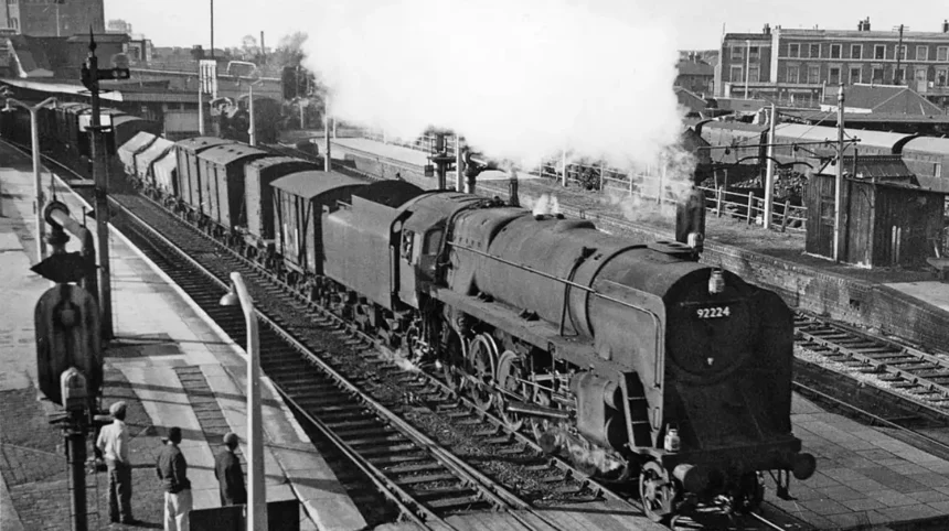
The opening of the Great Western Railway in 1838 marked another major development. The railway connected London with western England and helped reshape the geography of settlement, industry and commerce. Stations and railway infrastructure encouraged development around accessible locations.
Acton became associated with manufacturing and industrial employment as transport improved and land became available for factories and housing. Hammersmith and surrounding districts also experienced population growth and urban expansion.
Industrialisation created demand for accommodation, shops, schools, places of worship and public services. New streets and terraces accommodated workers and their families, while commercial centres developed around railway stations and major roads.
The environmental consequences were substantial. Factories, railways and growing populations increased pressure on land, air quality, sanitation and local infrastructure. Nineteenth-century urban growth therefore created both economic opportunities and new public health challenges.
By the end of the Victorian period, much of West London had become more closely integrated into metropolitan London. The rural landscape had not disappeared entirely, but urban development was increasingly shaping the area’s future.
How Did Victorian Railways Change West London?
Victorian railways accelerated West London’s urbanisation by reducing travel times, connecting residential districts with central London and supporting industrial growth. Railway stations encouraged housing development, increased commuting and helped transform places such as Ealing, Acton, Hammersmith and Richmond into increasingly accessible suburban communities.
The railway age changed how people selected where to live. Before widespread rail travel, journeys into central London often depended on walking, horse-drawn transport or road services. Railways made longer daily journeys more practical for workers and middle-class households.
The Great Western Railway became an important influence on the western side of the capital. Its main line connected London with destinations across western England, while suburban services subsequently supported local commuting.
The Metropolitan Railway, which began operating in 1863, helped establish the development of London’s underground railway network. Subsequent underground and suburban railway expansion improved access to districts across the capital, including parts of West London.
Railway access encouraged developers to construct housing near stations. Terraced streets, villas and larger suburban houses appeared as demand for accessible accommodation increased. Local shops, schools and services followed, supporting the growth of permanent residential communities.
Ealing illustrates this transition. Its railway connections helped transform it from a village-based settlement into a major suburb. Acton similarly benefited from transport links that supported residential expansion and industrial employment.
Richmond developed as a residential destination with strong transport connections and access to parks and riverside landscapes. Hammersmith also became increasingly connected to the wider urban economy through rail and underground services.
Railway development produced lasting geographical effects. Stations became focal points for commercial activity, and their surrounding areas often developed distinct identities. Modern West London continues to depend on this relationship between transport accessibility, housing demand and employment.
What Role Did the Thames Play in West London’s Economic History?
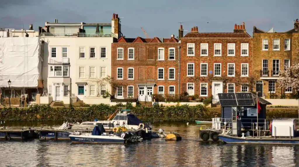
The River Thames shaped West London’s economy by supporting transport, manufacturing, trade and riverside settlement. Communities including Brentford, Chiswick, Hammersmith and Richmond developed in relation to the river, which connected them with central London and other parts of the Thames corridor while influencing local employment and recreation.
Before modern road and railway systems became dominant, rivers provided important routes for moving goods and people. The Thames connected riverside communities with London’s commercial centre and with ports and settlements farther downstream.
Brentford’s historic position near the River Brent and the Thames made it significant for transport and trade. Its commercial development also benefited from the nearby canal network, which connected London with industrial areas in the Midlands.
Hammersmith developed along a stretch of the river that supported local trade, transport and leisure. Its riverside identity became increasingly associated with public recreation, rowing and cultural activity as the city expanded.
Chiswick retained a connection with the Thames through its historic houses, open spaces and riverside neighbourhoods. Richmond’s riverside landscape also became an important feature of its residential and recreational identity.
Industrial uses changed the character of parts of the river during the nineteenth and twentieth centuries. Commercial facilities and industrial premises occupied sections of the waterfront, while pollution and changing transport practices affected river environments.
Later changes in industry and planning encouraged the redevelopment of some former industrial sites. Riverside locations increasingly accommodated housing, offices, leisure facilities and public spaces.
The river remains relevant to West London’s contemporary identity. It supports recreational activities, provides important ecological habitats and shapes the character of riverside neighbourhoods. Flood management, water quality and the protection of river ecosystems remain important planning considerations.
How Did West London Change During the Early Twentieth Century?
During the early twentieth century, West London experienced suburban expansion, transport improvements, industrial employment and changes in housing. Growing metropolitan populations encouraged new residential districts, while factories and commercial facilities supported employment in areas such as Acton, Brentford, Hounslow and Southall.
The early twentieth century continued the transformation that began during the Victorian period. Improved transport allowed residential development to spread farther from central London, while new roads and public services supported growing communities.
Suburban housing expanded across much of the region. Developers built family houses, terraced properties and larger residential streets to accommodate households seeking space outside the most densely populated central districts.
Industrial employment remained important. Manufacturing, engineering, food production and other commercial activities supported workers in several West London neighbourhoods. Proximity to railway lines and major roads made some districts attractive for factories and distribution facilities.
Southall developed a strong industrial and commercial identity, including important food-related businesses and transport-linked employment. Hounslow benefited from its position along major routes west of London, while Acton remained associated with manufacturing and working-class residential communities.
The First World War, from 1914 to 1918, disrupted industry and daily life. The Second World War, from 1939 to 1945, brought further changes through mobilisation, industrial production, air raids and damage to buildings and infrastructure.
West London contained strategically important transport and industrial facilities. The wider London region experienced extensive wartime disruption, and post-war reconstruction became a major influence on planning and housing policy.
The early twentieth century also saw changing expectations around public health, education, housing standards and local government. These developments laid the foundations for later improvements in social housing, urban planning and public services.
How Did World War II Affect West London?
World War II affected West London through air raids, industrial mobilisation, population disruption and damage to homes and infrastructure. Between 1939 and 1945, communities across the wider London region experienced wartime restrictions and emergency services, while the post-war period introduced reconstruction programmes and new approaches to housing and urban planning.
London’s industrial and transport infrastructure made it important to the British war effort. Factories, railways, roads and other facilities supported production and logistics, while workers contributed to military supply and essential services.
Air raids placed residential neighbourhoods and industrial districts at risk. Bomb damage disrupted homes, businesses and public facilities, creating immediate challenges for residents and local authorities.
Wartime evacuation also changed family life. Children and other civilians were moved away from areas considered vulnerable to bombing, while military service and industrial work altered household arrangements and employment patterns.
The consequences continued after the war ended in 1945. Housing shortages, damaged buildings and the need to modernise infrastructure influenced redevelopment across London.
Post-war planning aimed to improve living conditions through new housing, public services and changes to the urban environment. Some older buildings were repaired, while other sites underwent redevelopment.
The effects varied across West London because the region contained different combinations of industrial facilities, residential neighbourhoods and transport infrastructure. Nevertheless, the war accelerated changes already under way in housing policy, public administration and the organisation of metropolitan life.
The historical legacy remains visible in memorials, surviving buildings, local archives and records of wartime civilian life. These sources help explain how West London communities responded to a period of major national disruption.
How Did Immigration Shape West London’s Communities After 1945?
Post-war immigration reshaped West London through new communities, businesses, religious institutions, cultural traditions and international connections. Migration from the Caribbean, South Asia, Africa, Europe and other regions contributed to the development of neighbourhoods such as Southall, while changing local food, commerce, education and community life.
After 1945, Britain faced labour shortages in important industries and public services. Workers arrived from different parts of the Commonwealth and other countries, contributing to transport, manufacturing, healthcare and other sectors.
The arrival of Caribbean migrants, including people associated with the Windrush generation, formed an important part of Britain’s post-war social history. Caribbean communities contributed to London’s public services, transport networks, cultural life and local economies.
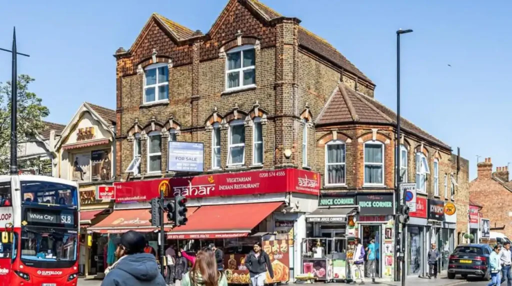
South Asian migration also transformed West London. Southall became particularly associated with Punjabi and wider South Asian communities, including people with roots in India and Pakistan. Shops, restaurants, clothing businesses, places of worship and community organisations helped establish the area’s distinctive commercial and cultural character.
These changes were not limited to Southall. Families and businesses from different backgrounds settled throughout Ealing, Hounslow, Hammersmith, Acton and neighbouring districts.
Migration influenced the retail and food sectors. Independent grocers, specialist food shops, restaurants and wholesale businesses served local residents while attracting customers from across London.
Religious institutions became important community centres. Sikh gurdwaras, Hindu temples, mosques, churches and other places of worship supported religious practice, community services and social networks.
West London’s cultural development also included music, festivals, language, education and public life. Local communities created organisations and businesses that reflected both their heritage and their experiences of living in Britain.
The region’s diversity remains central to its identity. Its neighbourhoods demonstrate how migration has influenced London’s demographic structure, commercial activity and connections with the wider world.
How Did West London’s Housing and Architecture Evolve?
West London’s housing and architecture developed through successive periods of rural settlement, Georgian and Victorian expansion, twentieth-century suburbanisation and contemporary redevelopment. Historic houses, terraced streets, mansion blocks, council estates and modern apartments reflect changes in population, wealth, transport access and public housing policy.
Architectural differences across West London reflect the region’s varied economic and social history. Older village centres contain historic buildings and traditional street layouts, while former industrial districts often feature Victorian terraces and commercial premises.
Kensington and Chelsea contain substantial areas of Georgian and Victorian architecture. Their residential streets include period houses, garden squares and mansion blocks associated with the expansion of fashionable London neighbourhoods.
Victorian terraces became common in areas that accommodated growing working populations. These houses provided relatively dense residential accommodation close to factories, railway stations and commercial streets.
Suburban development expanded during the late nineteenth and early twentieth centuries. Semi-detached houses and larger family homes appeared in areas where railway access made commuting more practical.
Public housing became increasingly important during the twentieth century. Local authorities developed estates to address housing shortages and improve living conditions. These projects formed part of broader national changes in housing policy and urban planning.
Post-war reconstruction introduced new building forms and redevelopment approaches. Some districts received modern housing estates, while older buildings were adapted or replaced to meet changing requirements.
Contemporary development includes apartment buildings, mixed-use schemes and conversions of former commercial or industrial properties. In locations with strong transport links, housing development often forms part of wider regeneration projects.
Planning controls also influence architectural change. Conservation areas protect the character of designated neighbourhoods, while listed-building status recognises buildings of special architectural or historic interest. These protections help balance redevelopment with the preservation of West London’s heritage.
How Did Heathrow Airport Influence West London’s Growth?
Heathrow Airport influenced West London’s growth by creating employment, supporting international travel and freight, and encouraging transport and commercial development. The airport’s expansion after the Second World War strengthened the economic importance of Hounslow and surrounding districts, while increasing pressure on housing, roads, public transport and the local environment.
Heathrow’s origins date to the early twentieth century, when the area contained agricultural land and airfield facilities. Following the Second World War, the site developed into a major civilian airport, with scheduled passenger services expanding from 1946.
The airport’s growth changed the economic geography of western London. Airlines, cargo operators, logistics businesses, hotels, retailers and other service providers created employment linked to aviation.
The surrounding area also attracted workers in transport, hospitality, engineering, security and other sectors. This employment supported demand for housing and local services in Hounslow and neighbouring communities.
International connectivity became another important factor. Heathrow connected West London with destinations across Europe and the wider world, supporting tourism, business travel and international trade.
Airport-related development also increased pressure on transport infrastructure. Road access, rail connections and local public transport became important for moving passengers and employees.
The Elizabeth line, which opened its central section in May 2022 and began operating as a complete through service later that year, improved connections between Heathrow, West London and destinations across the capital and beyond. London Underground services and other transport links also support access to the airport.
Heathrow’s presence brings environmental and planning challenges. Aircraft noise, air quality, road congestion and land-use pressures remain important issues for surrounding communities.
The airport therefore represents both an economic asset and a major planning consideration. Its influence extends beyond aviation into employment, transport policy, housing demand and West London’s long-term development.
How Did West London Develop During the Late Twentieth Century?
During the late twentieth century, West London experienced deindustrialisation, service-sector growth, changing retail patterns and major infrastructure development. Manufacturing declined in some districts, while offices, shopping centres, logistics facilities and new residential projects changed the uses of former industrial land and reshaped local employment.
From the 1970s onwards, changes in the British economy affected traditional manufacturing communities. Industrial restructuring, international competition and technological change reduced employment in some factories and workshops.
Former industrial sites increasingly became available for redevelopment. Depending on location and planning policy, these sites were converted into housing, offices, retail premises, leisure facilities or mixed-use neighbourhoods.
Brentford illustrates the transition from industrial and transport-related activity towards a broader economy that includes offices, residential development and commercial services. Other West London districts experienced similar changes, although the scale and timing differed.
Retail also changed substantially. Traditional high streets continued to serve local communities, but larger shopping centres and out-of-town retail developments introduced new patterns of shopping and employment.
Hammersmith developed as an important transport and commercial centre, while Ealing maintained a significant role as a suburban town centre with shops, services and transport connections.
Kensington and Chelsea retained major retail and cultural destinations, alongside high-value residential areas. In other districts, independent businesses and specialist markets continued to serve diverse local populations.
Public transport remained central to development. Underground lines, railway services and road networks connected residential areas with central London, Heathrow and employment centres elsewhere in the region.
The late twentieth century therefore changed West London’s economic structure without removing its older identities. Historic neighbourhoods, industrial heritage, suburban housing and newer commercial districts continued to coexist.
How Is West London Changing in the Twenty-First Century?
Twenty-first-century West London is changing through residential regeneration, improved public transport, commercial investment, environmental programmes and population growth. Projects across areas such as White City, Brentford and Old Oak Common illustrate efforts to reuse land, improve connectivity and create new homes, workplaces and public spaces within an established urban region.
Modern regeneration seeks to respond to housing demand, changing employment patterns and the need to make better use of previously developed land. The results vary according to planning decisions, infrastructure capacity, investment and local priorities.
White City has become an important focus of redevelopment in west London. The wider area includes commercial, educational, residential and cultural uses, alongside the legacy of earlier exhibition and industrial activity.
The former BBC Television Centre site illustrates the conversion of a major media complex into a mixed-use development. Its redevelopment introduced residential accommodation, workspaces, hospitality facilities and public areas while retaining significant elements of the site’s architectural identity.
Brentford has also experienced redevelopment associated with housing, commercial investment and changes to former industrial and riverside land. These projects reflect the wider shift towards mixed-use urban environments.
Old Oak Common is a major regeneration area in west London associated with planned transport infrastructure and long-term development. The wider Old Oak and Park Royal area contains industrial, logistics and employment sites alongside residential communities. Major transport proposals are intended to improve connections, although delivery schedules and development outcomes depend on funding, construction and planning decisions.
The Elizabeth line has already changed travel patterns by providing additional connections across London. Better accessibility supports commuting, retail activity and access to employment, while also influencing housing demand around stations.
Environmental planning is another important issue. Local authorities and developers increasingly address energy efficiency, public space, walking and cycling routes, drainage and green infrastructure.
These changes will continue to shape West London’s housing, employment and transport patterns. Their long-term effects depend on whether infrastructure, public services and development keep pace with the needs of existing and future residents.
What Makes West London’s Neighbourhoods Historically Distinct?
West London’s neighbourhoods have distinct identities because their development followed different combinations of royal influence, industry, transport, migration, housing and commerce. Kensington, Chelsea, Ealing, Southall, Hammersmith, Acton, Brentford, Hounslow and Richmond each preserve different elements of the region’s wider history.
Kensington is associated with royal connections, museums, garden squares and historic residential streets. Its development reflects proximity to central London and centuries of investment in prestigious housing and cultural institutions.
Chelsea has a strong architectural and cultural heritage. Its historic streets, riverside setting, galleries and retail destinations reflect a long relationship with affluent residential life and artistic activity.
Hammersmith developed around the Thames, transport corridors and commercial activity. Its modern identity combines residential neighbourhoods, offices, entertainment venues and major road and public transport connections.
Ealing retains a suburban character shaped by historic village centres, parks, housing and railway development. Its growth demonstrates how improved transport converted settlements beyond central London into established residential districts.
Southall is recognised for its South Asian communities, specialist shops, restaurants and religious institutions. Its commercial streets illustrate the influence of post-war migration on local business and cultural life.
Acton has a history connected with industry, housing and transport. Its location between central London and the western suburbs supported manufacturing and residential growth.
Brentford’s identity reflects the Thames, the River Brent, canals, industrial development and later commercial regeneration. Its waterfront and historic transport links remain important features of the area.
Hounslow developed along important routes west of London and has been strongly influenced by Heathrow Airport and related employment. Richmond combines historic buildings, riverside landscapes, parks and residential development.
These differences demonstrate why West London is best understood as a collection of connected communities rather than a single uniform district.
Why Does West London’s History Matter for Future Development?
West London’s history matters because earlier decisions about transport, housing, industry and landownership continue to influence modern planning, economic activity and community identity. Understanding these patterns helps residents, businesses and policymakers assess regeneration, protect historic buildings, improve infrastructure and respond to housing and environmental pressures.
Transport remains one of the clearest examples of historical influence. Railway stations helped establish suburban centres during the nineteenth century, while modern rail and Underground connections continue to influence development around accessible locations.
Housing patterns also reflect historical change. Georgian and Victorian streets, suburban estates, post-war housing and contemporary apartment buildings represent different responses to population growth and economic conditions.
Industrial heritage influences current regeneration. Former factories, warehouses and transport sites provide opportunities for new uses, but redevelopment also raises questions about heritage protection, affordable housing, employment and public space.
Migration remains central to West London’s social and economic structure. Established communities support local businesses, cultural institutions and international trade connections. Their history provides important context for understanding the region’s identity and future needs.
Environmental planning has become increasingly significant. Riverside development must account for flood risk and ecological protection, while transport planning addresses congestion, accessibility and emissions. Historic parks and green spaces also contribute to public health and local environmental quality.
West London’s future will depend on how effectively development responds to these interconnected issues. New housing and commercial projects require supporting infrastructure, including schools, healthcare, public transport and accessible open spaces.
Preserving heritage does not require preventing all change. It requires understanding the significance of historic places and making informed decisions about how they are adapted for contemporary needs.
Explore More Area Guide
Historical Events in West London: Key Moments and Landmarks
Famous Residents of West London: Celebrities and Icons
How Can Residents Explore West London’s History Today?
Residents can explore West London’s history through museums, historic buildings, parks, riverside walks, local archives and conservation areas. Visiting these places provides direct evidence of the region’s development, from royal estates and Victorian suburbs to industrial landscapes, cultural institutions and contemporary regeneration projects.
Kew Gardens, officially the Royal Botanic Gardens, Kew, provides insight into botanical research, landscape history and international plant collections. Its historic landscapes and scientific role connect West London with the development of botanical knowledge.
Richmond Park offers a different historical perspective. Established as a royal hunting park in the seventeenth century, it remains an important example of a historic landscape within metropolitan London.
Kensington Palace connects visitors with royal history and the development of Kensington as a prestigious residential district. Nearby museums and historic streets provide additional context for the area’s cultural and architectural development.
The Museum of London and local heritage organisations provide historical material about the wider capital and its communities. Borough archives contain maps, photographs, planning documents and records that help explain how individual neighbourhoods changed.
Southall’s commercial streets offer an opportunity to understand the area’s migration history through food businesses, specialist shops, religious institutions and community organisations. Respectful visits to places of worship and community sites help visitors appreciate their historical and present-day significance.
Riverside walks through Richmond, Chiswick and Hammersmith reveal how the Thames shaped settlement, recreation and transport. Canal-side routes near Brentford provide evidence of the transport infrastructure that supported industrial growth.
Historic high streets and conservation areas also reveal earlier patterns of development. Building styles, street layouts, former industrial structures and railway stations provide clues about the economic and social forces that shaped the region.
Exploring these places connects historical research with the living environment. West London’s heritage remains visible not only in famous landmarks but also in ordinary streets, local businesses and the everyday routines of its communities.
Conclusion: How Has West London Transformed Through the Decades?
West London has evolved through successive periods of settlement, agricultural development, industrialisation, suburban growth, migration and regeneration. Each period introduced new economic activities and social structures while leaving traces in the area’s buildings, transport networks and neighbourhood identities.
The Roman and medieval periods established elements of the wider regional landscape. The early modern era strengthened the importance of estates and prestigious residential districts. Industrialisation and Victorian railways then accelerated urban growth and connected western settlements more closely with central London.
The twentieth century brought suburban expansion, industrial employment, wartime disruption, reconstruction and significant post-war migration. These changes helped establish the diverse communities and economic networks that define West London today.
In the twenty-first century, regeneration, transport investment, environmental planning and housing demand continue to reshape the region. Historic neighbourhoods remain alongside new residential developments, commercial centres and modern infrastructure.
West London’s history is therefore not simply a record of buildings and dates. It explains how transport, employment, migration, landownership and planning shaped the communities that exist today. Understanding these connections provides a factual foundation for appreciating the region’s heritage and following its future development.
What is the history of West London?
West London’s history spans Roman Britain, medieval villages, agricultural estates, Victorian industrialisation, suburban expansion and modern urban regeneration. Railways, migration and economic development shaped its growth into a diverse part of Greater London.